
You might also like:
We’re taking a look back at some of our favourite articles from the past year
Linda Meads pulls over to admire some of New Zealand’s most picturesque roadside stops, from north to south and east to west.
The biggest challenge of a self-drive exploration of New Zealand is not our narrow and winding highways but keeping your eyes on the road and off the amazing scenery you’ll find around almost every twist and turn. Luckily there are loads of lookout spots from top to bottom so you can pull over safely to admire the beauty. Here are some of the finest sights worth stopping for.
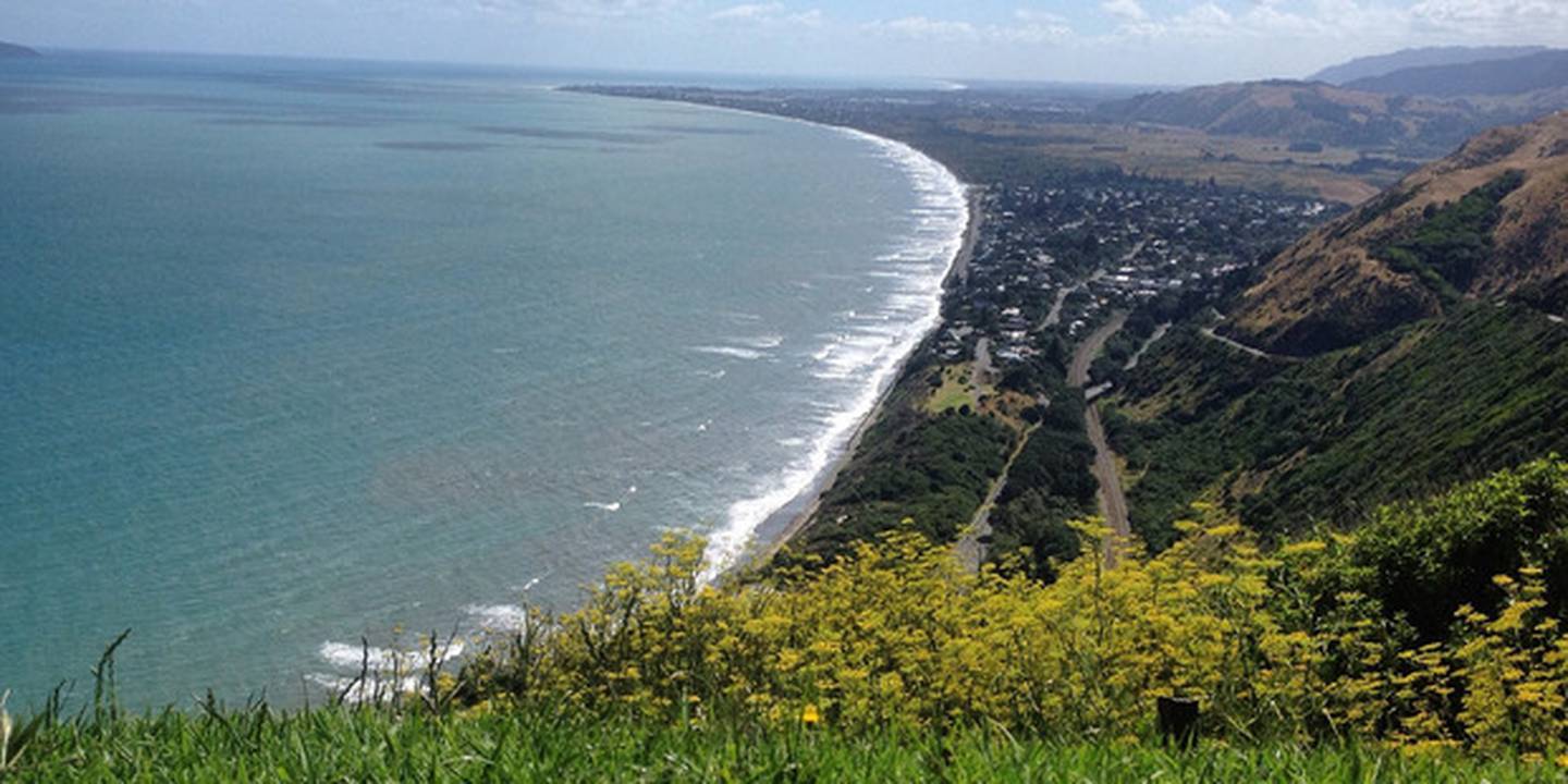
Paekakariki Hill, Kapiti Coast
The drive is not for the fainthearted but if you can get up and over the Paekakariki Hill — the former main road north out of Wellington — you’ll be rewarded with glorious far-reaching views of the Kapiti coastline north to Mt Taranaki on a good day, from a designated lookout point nearly 250m above sea level. It’s a slow way to travel — winding and often closed because of bad weather, the speed limit is just 60km/h — but the view from the top will take your breath away. Travelling north you can access the Paekakariki Hill Rd from the Hutt Valley via Pāuatahanui or if you’re heading south to the capital, veer left at Paekakariki itself, 40km north of the CBD on State Highway 1.
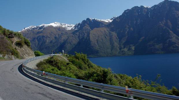
The Devil’s Staircase, Kingston
The natural beauty in every direction in Central Otago will have your jaw permanently dropped but one particularly special place to admire Lake Wakatipu is a lookout 30 minutes south of Queenstown. The Devil’s Staircase on State Highway 6 just outside of the small township of Kingston offers sweeping views of the region’s stunning landscape steeply dropping to meet the southern arm of one of New Zealand’s most famous lakes, while The Remarkables mountain range in all its glory looms large in the background. Equally spectacular are the lookout points on the northern part of the lake on the drive between Queenstown and Glenorchy.
East Cape Lighthouse, Te Araroa
You’ll have to negotiate 22km of mostly unsealed, windy road to get to the easternmost point of New Zealand on the North Island’s East Cape, but we promise the journey is worth it, both for the dramatic coastline-hugging views along the way, and those from the iconic lighthouse at the end. For the ultimate photo spot, climb the 700 steps to the base of this still-operational historic landmark which sits 154m above sea level on Otiki Hill offering stunning views of the area in all directions. To get there, you turn off State Highway 35 at the tiny settlement of Te Araroa.
Mt John, Tekapo
The Mackenzie region of New Zealand is rich in scenic showstoppers but one of its most spectacular is atop Mt John, just under 10km north of Tekapo off State Highway 8. One of New Zealand’s prime spots for light pollution-free star gazing, this South Canterbury mountain boasts its own observatory and New Zealand’s premier astronomical research centre, which happens to be home to the country’s largest telescope. A daytime visit offers an entirely different experience, with incredible views of the Mackenzie Basin including vibrant Lake Tekapo and the surrounding rugged alpine landscape from the glass-encased Astro Cafe at the summit. While you’re in the region, call by the sleek Aoraki/Mt Cook Visitor Centre in Mt Cook Village which offers premium views of this iconic New Zealand landmark, as well as unparalleled views of striking Lake Pukaki.
Huka Falls, Taupo
Taupo is a natural place to stop during any journey through the central North Island and it’s worth deviating from State Highway 1 just a few minutes north of the lakeside township for a breather at Huka Falls, one of the country’s most impressive waterfalls. Stretch your legs with a 10-minute stroll from the carpark to several lookout points offering views of the mighty Waikato River pounding its way through a 15m wide channel of hard rock to create a powerful volume of water. The resulting energy generated from the river’s gate-controlled flow over the falls is used to generate power for nine hydro-electric power stations, and means their height can vary from 7 to 9.5 metres.
Pancake Rocks and Blowholes, Punakaiki
The South Island’s West Coast has so many glorious photo-worthy stops that it’s hard to narrow down just one, but if we had to choose, it would be Punakaiki’s famous Pancake Rocks, roughly halfway between Greymouth and Westport. This miracle of Mother Nature, found on the Great Coast Road at Dolomite Pt, is comprised of a collection of stacked limestone rocks resembling, you guessed it, pancakes, that date back a good 30 million years or so. You’ll find an easy walking trail of just over a kilometre offering different viewpoints of both the rocks and three dramatic blowholes, which are particularly spectacular at high tide during a southwesterly swell. The area’s striking Paparoa Ranges provide a dramatic backdrop to all the action on this small section of State Highway 6.
Lion Rock, Piha
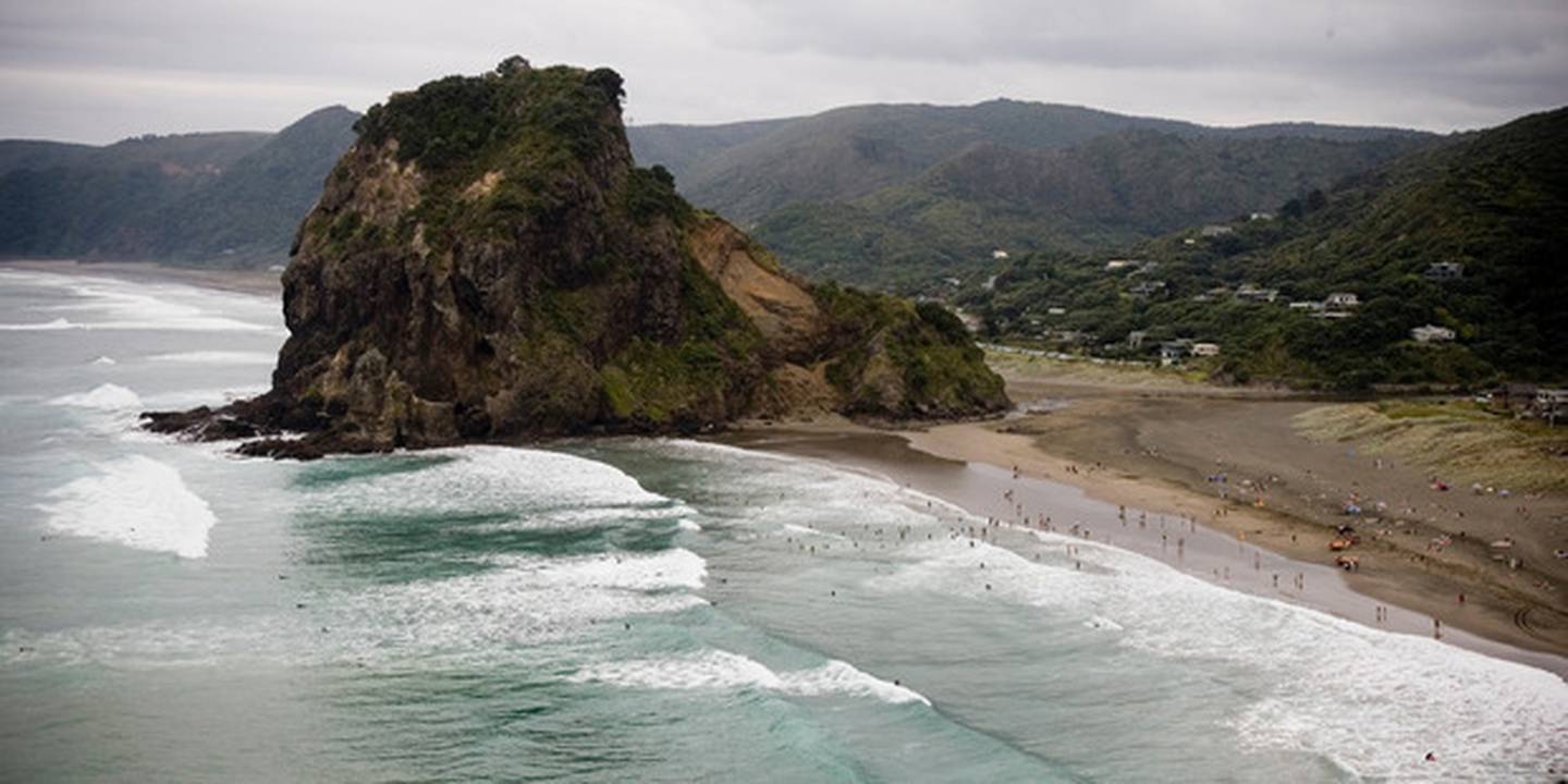
West Auckland’s wild and unruly Piha Beach is a dramatic sight no matter the weather with its wide expanse of black sand and crashing waves, but it is the beach’s iconic Lion Rock, or Te Piha, that gets all the attention in front of the camera. Sitting between Piha’s main and north beaches, the rock — a volcanic neck — is 16 million years old, and is best admired from a lookout point on the only access road that descends down to the small coastal settlement found 40km west of Auckland’s CBD. To see why it is named Lion Rock, however, you need to see it from behind on the shore side — from this viewpoint it looks like a male lion lying down. For another perspective of Piha Beach and its surrounds you can climb the rock itself, though the top third of its 100m is off-limits to walkers following a rockfall about 20 years ago.
Source: nzherald.co.nz