
You might also like:
A hair-raising flight over a Peruvian desert puts work of the ancients into perspective, writes Eleanor Hughes
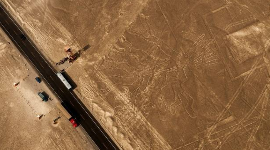
On the side of the Pan American Highway in the middle of nowhere stands a red metal viewing tower like the type used to watch over a prison. There doesn’t appear to be anything to view, other than light brown dirt strewn with hand-sized rocks, whizzing cars and roaring trucks on the highway, and reddish-tinged hills in the distance. Apparently, however, there are two figures drawn in the dirt. They are some of the around 70 which, along with lines and shapes make up what is known as the Nazca Lines.
For 3 sol, given to a man at the base of the tower selling dust-covered souvenirs and guidebooks in various languages, we’re allowed to climb El Mirador, 10 people at a time.
It wobbles as we go up. Fifteen metres higher, I see the figures — the outline of two hands, one with only four fingers and, to the right, a many branched tree. They’re not the size of something you’d draw with a stick on the beach, these are both 65m in length.
They’ve been made by removing the reddish rocks of the desert to expose the yellow earth beneath. It all looks brown to me but the outlines are very definite and precise.
From ground level the Nazca Lines are barely discernible, which is why the highway, built in the 1920s, passes straight through the figure of a lizard. Back then only a few archaeologists and locals were aware of the lines and thought they were irrigation ditches, having no idea of the extent of them. Imagine then, being a pilot in the 1930s, when flights began over the area, spotting lines as straight as a ruler travelling for kilometres criss-crossing the desert and intersecting triangles, rectangles and quadrangles drawn on the desert floor. And of course, the figures.
Several hours later, I’m surprised the flight I’m boarding has not been cancelled. The wind is tugging at my clothes and the flight is on a six-seater Cessna 206 that looks not a lot bigger than a model plane. In fact, I was kind of hoping it would be cancelled after just reading of tourists dying in plane crashes sightseeing the Nazca Lines. Safety has supposedly improved since two crashes in 2010 and I’ve wanted to see the lines ever since I’d heard about them. So here goes …
Taxiing down the runway, I’m wondering if it’s the last thing I’ll do in my life. A window on the pilot’s side flaps in the wind. I want to tell him, but I guess he knows what he’s doing … I hope.
We fly north, away from the dusty town of Nazca with its mainly single-storey buildings and grid-like layout. Fields in shades of green surround the town before being taken over by brown desert and hills like crumpled duvets, some tinged pink, some with great shadows in their creases. Far away I glimpse higher, green hills. The highway cuts the plain. The whiteness of dried up riverbeds twisting and wending their way across the land resembles a frothy, dirty sea. The plane tips to the right and I see the first figure, a whale.
It’s like viewing a picture on paper with a magnifying glass. The plane circles and tips left for the two passengers on that side to get a good view. We fly over triangles stretching into the distance, one apparently 3km long. They are not just outlines but fully cleared shapes as if mown into long grass. The flight banks above a hill and an astronaut waves.
Or is it an alien? Some call it an owl man and much smaller versions can be found on ancient Nazca pottery. Did aliens come visiting the Nazca people, or is it some sort of god figure which was worshipped, dreamed up by those who drank hallucinogenic drugs during traditional rituals?
The 30-minute flight with Alas Peruanas takes us over 14 of the figures. Some, like the spider, hummingbird and condor, are drawn so precisely it looks as though a mathematician has plotted points and then joined them up. The lines could have been formed by bulldozers, locked on straight ahead, their blade scraping across the desert with hills no obstacle. With the sun beating in and the movement of the plane, I try and take my mind off my queasy stomach and thoughts of crashing by focusing on the landscape below.
How on earth did whoever created the around 1000 lines, figures and 300 odd shapes know what they were doing? Many are out in the open, no hill near to climb and look out over them. Did their creators ever see what they drew in its entirety? The size of the figures is phenomenal — the hummingbird measures 93m in length, the monkey 90m.
The largest we see is a flamingo at 300m. Studies suggest the Nazca people created these geoglyphs somewhere between AD445 and AD605. But why?
Some say they form an ancient calendar or are to do with astronomy, others that the lines point to underground water or were used for ceremonies to find water. Other suggestions include being a form of communication with life from other planets, runways for extraterrestrial transport, ancestor worship, sacred gatherings or for the gods who would be the only ones who could see them in their entirety.
After landing back at the airport I review my photos. I managed to capture only one complete image. I should’ve spent the time enjoying the geoglyphs rather than trying to photograph them. Although it did take my mind off crashing. Should I go again?
Source: nzherald.co.nz